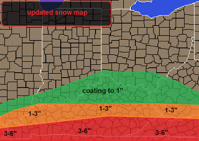
You can see here that I have the snowfall bands tiered just as I mention above. I think this is a good idea for snowfall. IN every section you could see over achieving bands of snow that could potentially up your totals by 1-2".
There are a lot of winter weather advisories out for Southern Kentucky, as the winter storm warnings have expired.
You can see the advisories here.
Now let's move onto the future weather. It's gong to be a different pattern of weather throughout the rest of winter. It will be a pattern that will hold 50° and 60° weather for three days and then turn cold. During these "cold event" that is when you have to look for an approaching storm, that could potentially lay a smacking on us as an UNEXPECTED guest. I'll show you what I'm talking about
Here we have a small clipper system that is working it's way across the area in the time period of this coming Sunday and Monday. If this storm tracks any farther to the south it will plummet that 32° line farther south. and then we could be looking at SNOW instead of rain. For this particular storm, it wouldn't be much of a snowfall accumulation. We will see how that storm will trend in the coming days. I expect it to probably stay at about the same place that it is.
This is the track I like for that system, It's borderline from being able to bring colder air in with it.
This is my current five day forecast. I'll likely need to add some precipitation into the forecast on Sunday and Especially Monday.


No comments:
Post a Comment