Current 5 Day Forecast:
As you can see above I do see a slight increased risk of a snow maker later on in the week. Some models have begun to trend north with the late week storm. That's good for us, if you wanna snow day. This is what the NAM is showing, in terms of the track of the storm.
Wow, it's taken a turn for the north. There will be a lot of cold air in place as this storm moves in, there be no need to worry about rain spoiling our snow maker. Now since that cold air is in place the snow ratio's will be higher. If we can get enough moisture that would usually create 1" of snow, it would be cold enough to turn that into 3" of snow. That's what the NAM is showing for our area.
As of now this is where the track of the storm will be, it can change and I wouldn't be surprised to see it come farther north. But one thing needs to be clear here, I don't think it will come far enough north to create an all out snowstorm of 6"+, but I do think 3-5" would be possible for a far Northern Track. We shall see
Oh I almost forgot, the GFS isn't far behind the NAM with it's track either....
This is the GFS ensemble, it takes the 00z,6z,12z and 18z runs and combines them together to get a smoother look at what the ACTUAL model thinks. This would be a nice snow maker here as well. Once again, not a huge snow storm for our area, but certainly an outside shot at 3-5" snow, especially the farther south you live.
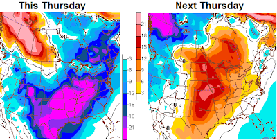
OKAY ENOUGH OF THE SNOW AND COLD WEATHER LET'S LOOK AT THIS THURSDAY AND NEXT THURSDAY.
WOW, what a major difference in temperatures from a weeks time. Thursday is likely to feature a little bit of colder air than the current 5day forecast that I have out right now. I am just waiting to verify that before I make any sudden changes. So this thursday according to that map has a chance at a high temperature of only 11° degrees and next Thursdays high temperature would likely be around 40°.
What am I saying?
I'm saying, next week we have a shot at 60° weather here in the Ohio Valley and I can't rule out a possible 70° day. How long does that stick around, well let's say a week and a half and WINTER RETURNS. Typically in La Nina season such as this, have a tiered February, cold at the beginning, warm middle, cold at the end. This would likely warrant some late season snow storms, into March and EVEN APRIL! WOW!! But let's take care of March and April when we get there.
That's All I have for now, I'll be updating later in the afternoon to see if we need to update any possible winter weather events. Have a great day.


No comments:
Post a Comment